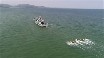


The Pohang Georesources Demonstration Research Center of the Korea Institute of Geoscience and Mineral Resources, together with the National Institute of Marine Cultural Heritage, started a joint exploration using the 'Coastal 3D Seismic Exploration System (EOS3D)' in the sea area where the Battle of Myeongnyang was held in Jindo, Jeollanam-do. EOS3D is the principle of estimating the structure of the subsea stratum and objects buried in the sea bed by recording the acoustic frequency signal reflected from the sea floor and analyzing the reflection characteristics.
The technology that produces an image from the signal reflected from the surface of an object after shooting sound waves has been used in the past. However, a highly precise 3D image is required for the underwater cultural heritage exploration, which involves the divers' laborious diving investigation after marking an object on the bottom of the sea floor, because the temporal and physical limitations of the diving investigation must be taken into account. It took several years to develop a technology that can analyze sound wave signals and precisely calibrate the location information to mark the exact location of the probe.
Real-time localization (RTK)-GPS technology was also combined to precisely grasp the location of buried chim-seon traces and cultural assets at the level of several centimeters. This technology is a state-of-the-art system that corrects real-time location information errors during movement and is being applied to unmanned moving objects such as drones.
|Customer use cases


.png)
.png)


